Wind gusts could hit 70 miles per hour or higher in the town of Neah Bay, Washington tonight, according to weather forecasts.
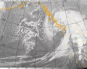
The cause of the storm is a “very low pressure (system) that’s developing right now off our (Washington) coast. Now it may be the lowest (barometric) pressure we’ve ever had offshore here, or it will tie it.”, University of Washington Atmospheric Sciences Professor, Cliff Mass, tells KVI.
Speaking to KVI morning host, John Carlson, Mass says “this storm is so powerful it is the equivalent of a Category 3 or maybe even 4 hurricane.” But the heart of the storm will travel north–away from the Washington coast, toward Vancouver Island–instead of west into the peninsula beaches.
Weather forecasters call the storm a ‘bomb cyclone’ because of its rapid intensification within a 24-hour period, says Mass.
To hear Carlson’s interview with Professor Mass, click the play button below.
Mass adds, “The only reason we don’t call it a hurricane is because it formed not over warm water…but over the (colder water of) Pacific Ocean. It’s energy source is different, but in terms of its strength–the wind speeds–its equivalent to a major hurricane.”
Mass says the Western slopes of the Cascades will also see severe winds gusting to 50 miles per hour tonight for towns from Eatonville to North Bend. Residents are being warned to avoid Cascade Mountain travel due to snow and possible blizzard conditions on highways brought on by the east-southeastern wind flow. Pictured below is a map of predicted windspeeds. Click on the embedded link to make the graphic larger.
⚠️ An anomalously strong storm system will generate strong easterly winds across western Washington later today into early Wednesday morning. Be sure to:
🍃 Secure loose outdoor items.
🌲 Stay clear of trees and downed power lines.
🕯️ Prepare for power outages.#WAwx pic.twitter.com/gAvZGgD8pN— NWS Seattle (@NWSSeattle) November 19, 2024


